The tide mill on Mill Hill Island has been on my list of South Wellfleet sites to be investigated for a long time. A short note posted on the Wellfleet Historical Society’s e-news this fall caught my eye: someone in Truro was looking for information on it too. Soon, we had an email exchange going, and I started researching the site.

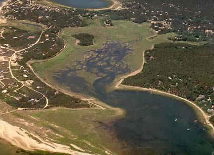
Satellite photo of Lieutenant’s Island showing Mill Hill Island circled in red
Like many Cape towns, Wellfleet has the reminder old mills, both wind and water-driven, in street names and water bodies. Wellfleet’s map shows Mill Hill Road, Old Mill Way, Mill Creek, and Mill Creek Lane. A South Wellfleet pamphlet printed in 1938 refers to the “Mill Ditch” near Cannon Hill. Mr. Deyo’s book written in the 1890s describes the old Wellfleet house, now called Morning Glory, which was the former windmill on Mill Hill. The other old mills, like the Tide Mill on Mill Hill Island, have disappeared.
Mapping the Old Mills
In 1793, Levi Whitman, Wellfleet’s minister, wrote “A Topographical Description of Wellfleet” that is preserved today in the records of the Massachusetts Historical Society. He wrote about Wellfleet, “The inhabitants do not raise grain sufficient for the town. The common method is to import it from the southern states. We have for grinding it into meal, five windmills and one tide mill.”
On the 1795 map of Wellfleet (https://www.digitalcommonwealth.org/search/commonwealth:2227nh08z) there is our tide mill (labeled water mill) on Loagy Bay in South Wellfleet and also windmills on Bound Brook Island, east of the Meeting House on Duck Creek, east of the County Road, on today’s Mill Hill, and further north, south of Herring Brook. In addition, there is a water mill on South Wellfleet’s Drummer Pond which turned out to be a fulling mill, a topic covered in an earlier post.
In Everett Nye’s Wellfleet history book written in 1920, he describes another tide mill “located in the creek below the Hamblen place” built by Thomas Holbrook, but no year is mentioned.
The tide mill in today’s South Wellfleet may have been built when the area was still a part of Eastham. Early in the town’s history, in the 17th century, mills were part of the business of the town, and there are numerous references to them in the town meeting notes that have been reconstructed up to 1692. According to an article in the Cape Cod Genealogical Society’s magazine, the oldest mill in town was a tide mill in the stream that connect Salt Pond to the harbor. It was built by Thomas Paine Sr. who became well-known as the town’s millwright, training his sons in the same occupation. One source cites some ten mills the Payne/Paine father and sons built on Cape Cod, tide mills, water mills, and windmills, from 1641 to 1711.
The South Wellfleet Tide Mill
There is no recorded image of the South Wellfleet tide mill. To understand how our mill might have looked, or how it operated, I looked for information about tide mills in general, and old photographs of extant tide mills to gain an understanding. This led me to the Tide Mill Institute, accessible here: https://www.tidemillinstitute.org/
About Tide Mills
The Tide Mill Institute has this definition of a tide mill:
A tide mill is quite simply a water mill that derives its power from the rise and fall of the tides. It is almost never referred to as a “seawater” or “saltwater” mill because the chemical composition of the water driving the mill wheel is not important. What counts is that the water impounded behind a mill dam can only be put to work after the water level outside of the dam has sufficiently dropped during the ebb tide.” [The Tinkham Brothers’ Tide-Mill by J.T. Trowbridge. Edited and with Commentary by Richard A. Duffy. Arlington, MA: Arlington Historical Society, 1999]
The definition continues,
The following description comes from the exhibit brochure moinhos de maré do ociente europeu 2005:
“A tide mill comprises the building which houses the milling machinery, the mill-pond, where the tidal water is retained, and the dam or causeway which confine and controls it.
Sea water enters the pond through large sluices or “sea gates” which open under pressure from the rising tide, and close automatically after high water. By opening the internal sluice gate, the pressure of the water from the mill pond can be controlled as it flows through one or more narrow channels before hitting the paddle blades and setting the water wheel and the milling machinery in motion.”
There were tide mills all along the east coast of North America, from Newfoundland to Georgia, according to one writer about historic mills, Theodore Hazen, who wrote a detailed description in an article cited below. He notes that there were some mills specially constructed to operate on low level tides. He suggests that tidal mills may have been better than stream or water-powered mills because they don’t freeze as readily as a stream-operated mills. Tide mills are not subject to flooding events or low water periods that make operation difficult. With a tide chart, the mill operator can predict the time of operation, although, Hazen suggests, that time could be at four in the morning.
Indeed, the 1795 Wellfleet map shows a small mill pond next to the mill on Loagy Bay. The same writer notes: “Since the head of the water was low, these mills needed an undershot wheel and a dam had to be bult to achieve the desired head of water.”
Recently, the Tide Mill Institute released a video of the tide mills of Kittery, Maine. It is accessible here:
https://www.tidemillinstitute.org/new-tide-mill-video-not-just-for-locals/#more-2320.
One undated photograph of an old tide mill in Yarmouth Port, along with the photo on the Institute’s home page, show the type of building that might have been erected on Mill Hill Island in South Wellfleet.

An old Photo of the Tide Mill at Yarmouth Port
These visual tools helped me understand how our tide mill might have looked in the landscape. After looking at various maps (pictured below), particularly the Miles Merrill Plan/Map of 1890, and hearing descriptions of old stones, it may be that there was a “road” of stones approaching the Island from the northeast, as all the owners of the mill and island were located there. Other stones, between the nearest upland and the island, may have served as the mill’s dam. The 1790 map, showing a mill pond located to the right of the mill’s location, where the water created by a dam would have been stored.
I was able to discuss Mill Hill Island with several people who are familiar with the area who describe the old stones as part of the landscape. One member of the Eastman/Barker family whose property is still to the north, remembers jumping on the old stones to get across to Mill Hill Island where they played as children. Another person remembers stones that formed a road to the Island. A Paine family member recalled that she was told that the old millstone was moved into Blackfish Creek to serve as an anchorage for one of the fishing boats.
Ownership of the Tide Mill
The earliest deed found (so far) is the October 6, 1789, document filed in Barnstable on October 9, 1789, when Ezekiel Harding sold his “homestead, meadow and buildings” to John Witherell (spelled “Withrel” in the deed) for 220 pounds lawful money. Like other 18th Century Barnstable deeds, it is labeled 999121-244. There are two additional deeds near the same time moving other property from Harding to Witherell.
These deeds are rich with neighbors’ and geographical names that help us locate property today. Since these handwritten deeds are indexed only by the property owner’s name, finding landscape designations such as “tide mill” requires careful document examination. Fortunately, I was guided by an article in the Cape Cod Genealogical Society’s magazine written by Mary Magenau in the 1980s, and a list of deeds Chet Lay provided. The tide mill and Mill Hill Island continue to be mentioned in 19th century deeds transferring the property between neighbors, but there’s no indication of a building still in existence. Once the mill stopped working, the building’s wood may have been re-purposed for something else, as was typical in Wellfleet. When John Witherell died, in 1838, he was in debt, and his wife sold off much of his property to meet his obligations.
Various members of the Harding family moved to Maine. As Mrs. Magenau pointed out in her article, the Harding family benefitted from the allocation of land in Maine to the families of the men who fought in the 1677-1678 King Philip’s War, particularly the “Narraganset tract” which became Gorham, Maine. Ezekiel Harding’s grandfather, Joseph Harding, was in that battle and was granted land. One of Ezekiel’s brothers, David Harding, became one of Gorham’s leading citizens. In a very detailed history of Gorham, however, there is no mention of Ezekiel Harding.
Harding family members went to other towns in Maine in the mid-18th and early 19th centuries, but I could not find a definitive record of Ezekiel Harding. On the other hand, he is not listed in the 1790 Wellfleet census, nor is there a burial record for him in either Wellfleet or Eastham. When he transferred his property to John Witherell, he was nearly 70 years old and may not have lived much longer. There is an “Ezekiel Harding” in Bucksport, Maine, in 1790 but he appears to have a young family from the household ages, although it’s possible that this is the man from South Wellfleet. A number of family trees on Ancestry show that the Ezekiel Harding born in 1719 (the son of Abiah Harding) has a son Ezekiel born in 1768, who was buried in Bucksport in 1843, but the sources for this information are not well-documented. One other interesting fact about Ezekiel Harding is that he was a Baptist, as mentioned in Enoch Pratt’s book about the history of Eastham and Wellfleet. Ezekiel Harding was relieved of his payment to support the local church. This religious persuasion was still rather radical in New England at this time.
Ezekiel Harding’s father, Abiah Harding, may have been the owner or even the builder of the South Wellfleet tide mill. Since mills may have been under public permit, or were even subsidized by the towns, I looked through many pages of the 18th Century Eastham Town meetings, but did not find any such record. (I learned that the early mills were so important that millers were exempt from military service.) Work on searching town records will continue.
In this search I did find the inventory of Abiah Harding’s property when his estate was settled in 1744. However, there was no mention of particular tools that might have served his work as a miller; most of his possessions appear to be related to farming. The inventory also named numerous neighbors to whom he owed money, including his son Ezekiel. I have not found (yet) a recorded will in which he transferred his real estate to his sons, although the existence of the inventory suggests that his estate settlement was well-recorded. In another deed, his son John Harding refers to South Wellfleet land left by his father “Obior.” This reference confirmed my assumption that Ezekiel owned his land and the tide mill through a grant from his father.
There is more research to do once our Pandemic is over and we can access public records that are not already online today. I’m hoping to be able to spend some time in the basement of Town Hall looking at the Wellfleet records for the latter part of the 18th century, and will continue looking at Eastham property as well.
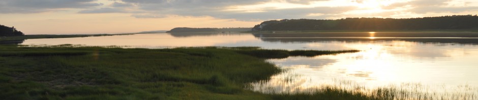
Mill Hill Island today
Mill Hill Island passed through numerous owners during the 19th Century. In 1842, Ruth Witherell, John’s widow, sold it to Robert Y. Paine to help settle the Witherell debts. Paine sold it to David Wiley and Ephraim Stubbs in 1862. When the Wiley children sold off his estate in 1890 to George Baker, the island was included. Baker re-sold it to Miles Merrill who developed the plan for the “Wiley Estate” then described as eleven acres, and today various owners of land there are all designated as part of the Merrill Plan. One owner recently donated property to the Wellfleet Conservation Trust.
The Merrill Plan map, pictured below in an upside-down view, shows how relatively far to the southwest the Island and the mill were from the property owners. For me, this made the references to a stone bridge and a stone road understandable.

The Merrill Plan with Mill Hill Island shown in the same perspective as the other maps
Mill Hill Island was never developed. Bruce Eastman remembers playing there as a child and sent this description:
Here is what little I know of the mill: There is a hill (essentially an island) we called Mill Hill which abuts our old property to the south. We were told there used to be a tidal mill on the east side of the hill, and there were still some remnants of pilings remaining when we were kids.
My compass directions are approximate. The hill faces Loagy Bay to the west, and the Lt. Island bridge to the south. There is a channel that runs between the east side of the hill and the “mainland”. There is tidal marsh between the hill and our property to the north. There used to be a “stone bridge” over a tidal ditch in the salt marsh between our property and Mill Hill. I believe there was reference to this “bridge” in the old documents describing the bounds of our property. There were still remains of this bridge, pretty well sunken into the marsh, when we were kids. We used to jump over the ditch on these remains to go over to play on Mill Hill. When we were kids someone had built a duck blind on the beach on the west side of the island, and it fell into disrepair as we grew up.
Denny O’Connell of the Wellfleet Conservation Trust was kind to send emails to me confirming that Mill Hill Island today is jointly owned by the Wellfleet Conservation Trust and the Town of Wellfleet, and is under the care of the Conservation Commission. He provided the map below.

Mill Hill Island of the Wellfleet Conservation Trust map
In addition, he introduced me to Michael Parlante, who owns a portion of the flats on the southeast edge of the Island and who is familiar with the area. Michael and I chatted one day about his memory of the site and the stone road that crossed the marsh to the east side of the island.
Stay tuned for more on the tide mill of Mill Hill Island.
Sources
Collections of the Massachusetts Historical Society Volume IV 1795, available at Google Books
The Tide Mill Institute at https://www.tidemillinstitute.org/
Deyo, Simon. History of Barnstable County, New York, 1898
Nye, Everett History of Wellfleet from Early days to Present Time 1920 (online at Google Books)
Dennis-Yarmouth Register old photograph of the mill in Yarmouth Port, available on the Register Archive at the Sturgis Library
Eastham Town Meeting records available at the Eastham Library’s website
Jeremy Dupertus Bangs, editor, The Town Records of Eastham During the Time of Plymouth Colony 1620- 1692, (Publication of the Leiden American Pilgrim Museum, 2012)
Hazen, Theodore R. “Preservation of Historic Mills” found here: http://www.angelfire.com/journal/millrestoration/historicmills.html
1790 Map at www.digitalcommonwealth.org
Mary Stubbs Magenau “A Vignette of Wellfleet History” Cape Cod Genealogical Society Bulletin VOL XIV no 2, page 37.
Cape Cod Genealogical Society Bulletin Volume III, No 3 re: tide mill on Salt Pond, Eastham
Conversations and Emails with Denny O’Connell, Wellfleet Conservation Trust, Michael Parlante, Irene Paine, Tim Richards, Bruce Eastman and Chet Lay.
|
|